
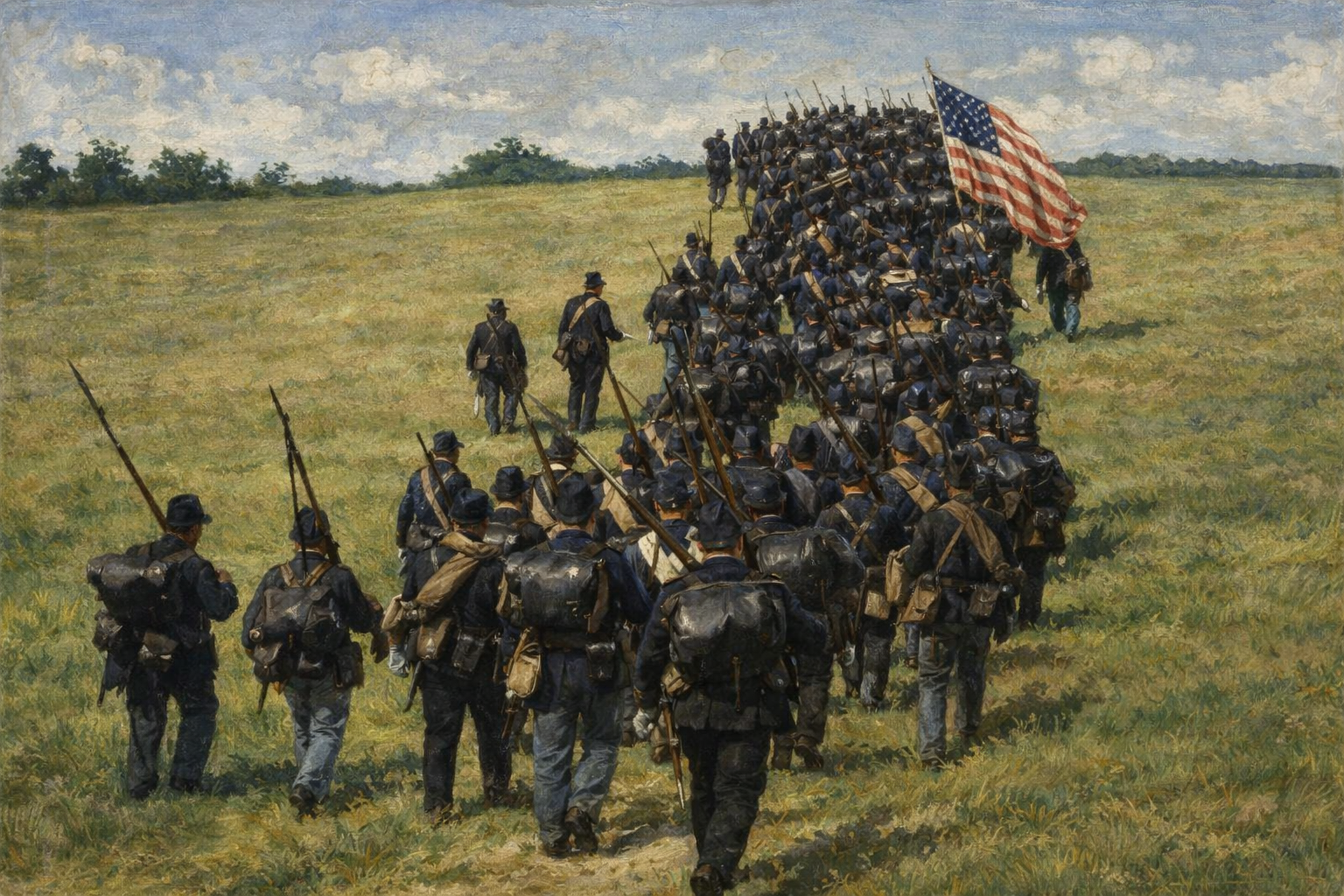
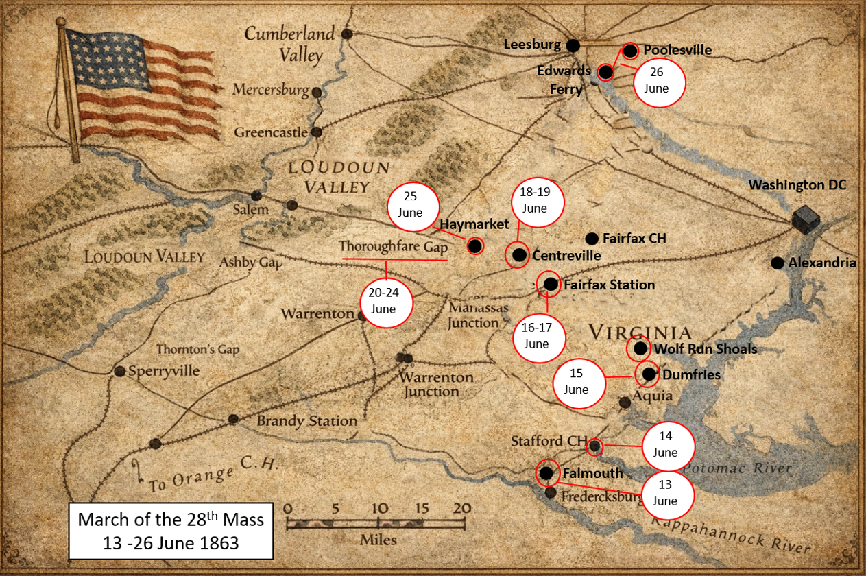
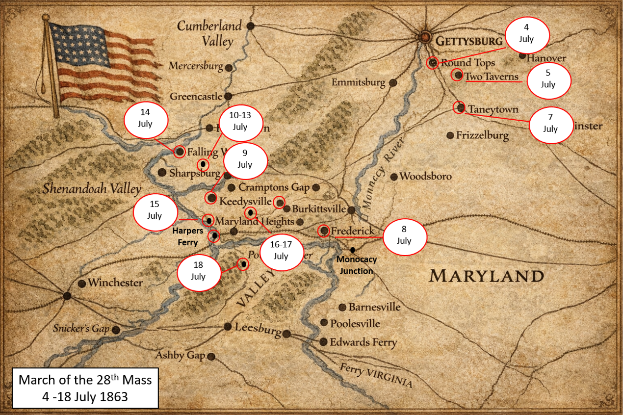
Introduction. Over the course of three hot weeks in June 1863, the 28th Massachusetts Volunteer Infantry marched nearly 200 miles to Gettysburg, entering the historic battle on its second day (2 July.). Below we will follow along day-by-day, as the Regiment moves towards its heroic fight. To set the scene the below maps give a broad overview of the total march.
13 June 1863 – Saturday – 1st Day on Campaign.

On Saturday 13 June 1863, the 28th Massachusetts Volunteer Infantry, 224 strong, is under the command of Colonel Richard Byrnes. The Regiment is assigned to the Second Brigade (the Irish Brigade) (Colonel Patrick Kelly), 1st Division (Brigadier General John C. Caldwell), II Army Corps (Major General Winfield Scott Hancock), Army of the Potomac (Major General Joseph Hooker). General Hooker has issued orders to have the Army of Potomac move north in pursuit the Confederate Army of Northern Virginia, whose lead elements are near Winchester, VA..
The 28th Mass breaks its camp near Falmouth VA and moves several miles to the Rappahannock River for Picket Duty (at or near Deep Run.) On picket duty, the soldiers of the Regiment experience severe thunderstorms. This concludes the Regiment’s 1st day on Campaign.
14 June 1863 – Sunday – 2nd Day on Campaign.
Falmouth, VA – Banks of the Rappahannock River.
On Picket Duty until nightfall. Very hot. The Regiment marches after dark. II Corps is part of what General Hooker labeled his “Second” wing and is moving in close coordination with the VI and XII Army Corps as well as the Reserve Artillery. II Corps is the Rear Guard of the Wing and accordingly, has spent much time rounding up stragglers — plenty to be found in the dry and dusty conditions.
The first day’s march takes the Regiment the short distance to Stafford Courthouse. (The route parallels modern US Route 1 North.)
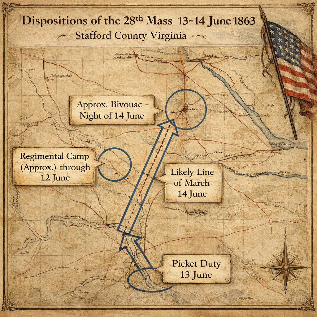
Total Distance Covered: 8 Miles.
15 June 1863 – Monday – 3rd Day on Campaign.
Stafford Courthouse, VA to Dumfries, VA – 13 Miles.
The Regiment marched daylight to dusk – likely along the trace of modern US Route 1 – bivouacking in woods near Dumfries. VA. Some accounts indicate II Corps HQ is located near Aquia Virginia, four miles north of Stafford Courthouse. It is likely II Corps is strung out along the road between Aquia and Dumfries (a distance of an additional 10 miles.)
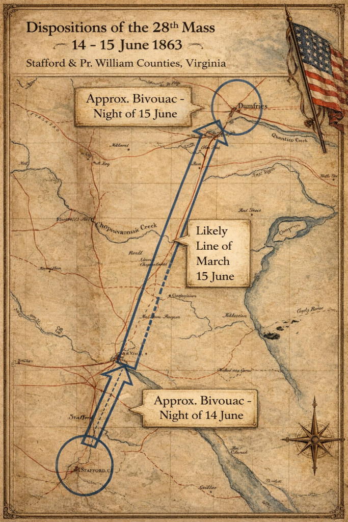
Total distance covered since 14 June is 21 miles.
16 June 1863 – Tuesday – 4th Day on Campaign.
Dumfries, VA to Fairfax Station, VA – 21 Miles.
The Regiment passes through Dumfries at 0800, turning Northwest across Prince William County to Wolf Run Shoals on the Occoquan River – a point about 10 Miles west of the village of Occoquan. The 28th Mass fords the Occoquan about 7PM. Some soldiers jump in water to cool off, but there are snakes. The Regiment bivouacs near Fairfax Station on the Orange & Alexandria Railroad, (Also known as “Sangster’s Station”), a few miles east of Clifton VA, according to Private John Ryan.)
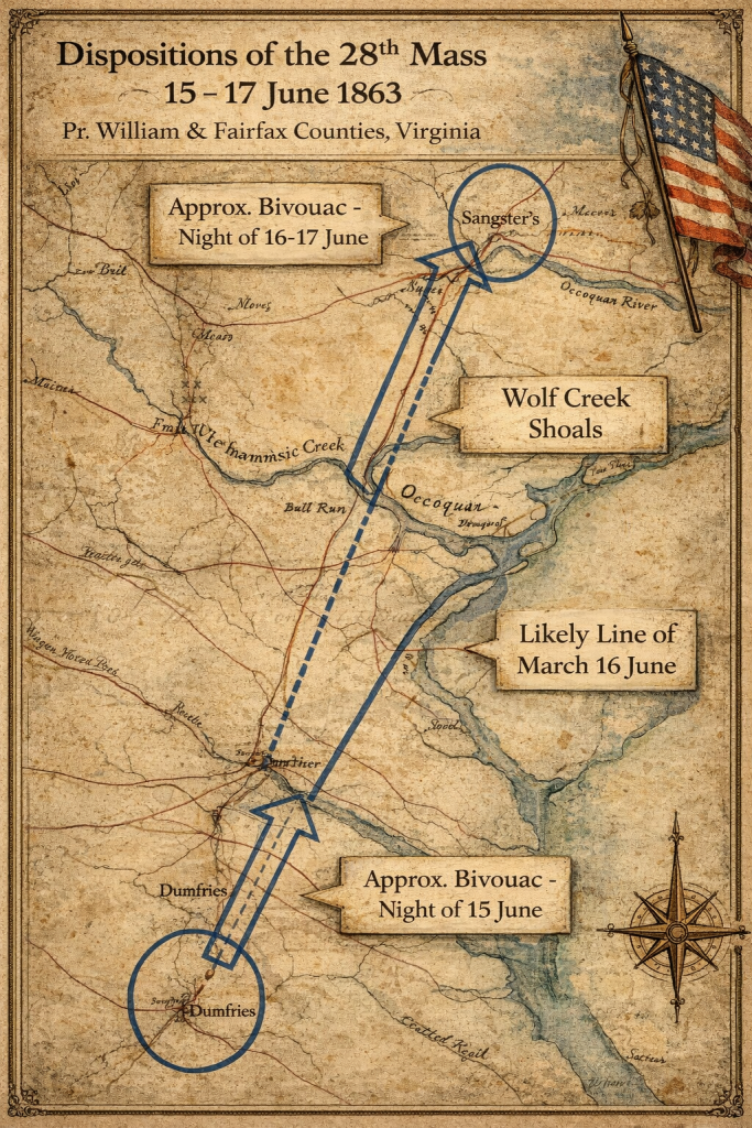
Total distance covered since 14 June is about 42 miles.
17 June 1863 – Wednesday – 5th Day on Campaign.
The Regiment remained in camp near Fairfax/Sangster’s Station, VA. Surplus baggage and equipment is collected and sent to storage in Alexandria, VA. The men understand this to be a sign of a coming battle.
18 June 1863 – Thursday – 6th Day on Campaign.
Fairfax/Sangster’s Station, VA to Centreville, VA – 9 Miles.
The Regiment marched at 2PM and encamped in the fortifications at Centreville. Rain & thunder break up the heat
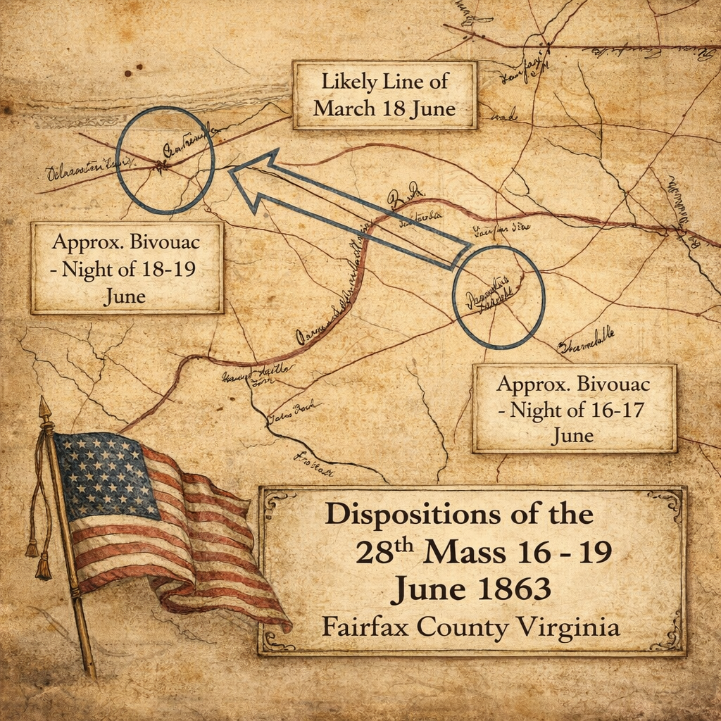
Total distance covered since 14 June is about 51 miles.
19 June 1863 – Friday -7th day on Campaign.
The Regiment remained in camp in Centreville, VA.

20 June 1863 – Saturday – 8th Day on Campaign.
Centreville, VA to the Thoroughfare Gap, VA – 20 miles.
The Regiment marched at midday from its bivouac location in “old fortifications” at Centreville, routing via Groveton, Haymarket, and Gainesville to the Thoroughfare Gap in the Bull Run Mountains. (Just east of present day Marshall, VA, along I-66). The route took the Regiment across the August 1862 2nd Bull Run battlefield. Private John Ryan recounts seeing skeletons exposed by recent hard rains. Roads very bad – wet & muddy. Halted near midnight near the mouth of the Gap after going 20 miles.

Total distance covered since 14 June is about 71 miles.
21 -24 June 1863 – Sunday – Wednesday – Days 9-12 on Campaign.
The Regiment spends these days on “Grand Guard” (by practice, called “picket duty,” with the outer sentinels called “pickets”) on the west slope of the Bull Run Mountains at the Thoroughfare Gap. (Just east of present day Marshall, VA, along I-66). The Regiment’s mission is to “oppose and obstruct the enemy at all hazards.” Private John Ryan recounts seeing Confederate supply trains moving in the distance.

The Grand Guard is a force thrown out in the direction of the enemy to prevent surprise, to give notice of his approach, to delay his advance, and give the main body time to prepare for battle, or make good its retreat. (See August V. Kautz, Customs of Service for Officers of the Army (Philadelphia: J.B. Lippincott & Co., 1865), 36-43.) The II Army Corps had this mission on the western flank of the Army of the Potomac as the Army of Potomac moves north in pursuit of the Army of Northern Virginia.
25 June 1863 – Thursday -13th Day on Campaign.
Thoroughfare Gap, VA to vicinity of Haymarket, VA – 22 or 23 miles.
The Regiment ends its picket duty in the Thoroughfare Gap and, along with the rest of the II Army Corps, gathers itself to move north and close with the rest of the Army of the Potomac. The Regiment moves out in the mid-morning under clear skies between 9AM and 10AM east towards Haymarket, a distance of approximately 18 miles. There is sporadic contact with elements of JEB Stuart’s cavalry who are beginning their ride around the flank of the Army of the Potomac; Company B has 2 men captured –one near the Gap and the other near Haymarket. The presence of large Federal forces on the eastern side of the Gap causes Stuart to veer south and further east than intended, which will keep Lee blind to the movements of the Army of Potomac’s movements for a longer period, to the benefit of the AoP.


Private John Ryan recalls that the Regiment bivouacs at “Green Springs”; Sergeant Peter Welsh recounts it in a letter to his wife as “Pleasant Valley.” I haven’t been able to locate either place on modern maps but I presume that they are likely no more than 5 miles North or East of Haymarket. I reach this conclusion by working backwards from Edwards Ferry, the locale the regiment reaches the following day in the afternoon, after an early start. Given that it is approximately 27 miles from Haymarket to Edwards Ferry, deducting 5 miles and adding that distance to the march of 25 June, takes each day’s average to the 22 or 23 mile range.
With this estimate in mind, the total distance covered since 14 June is about 93 miles.
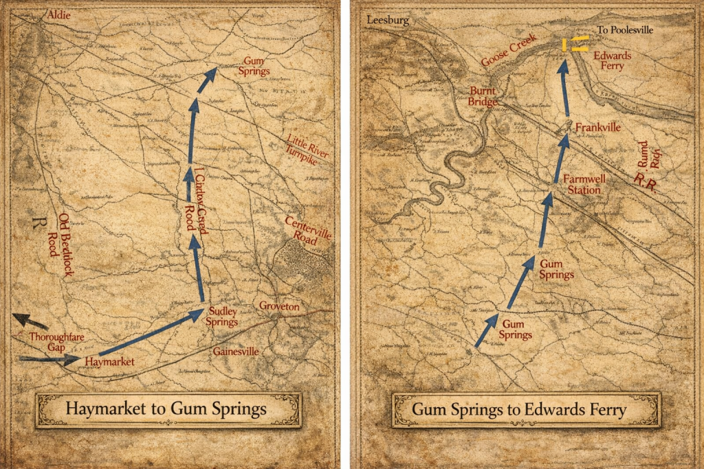
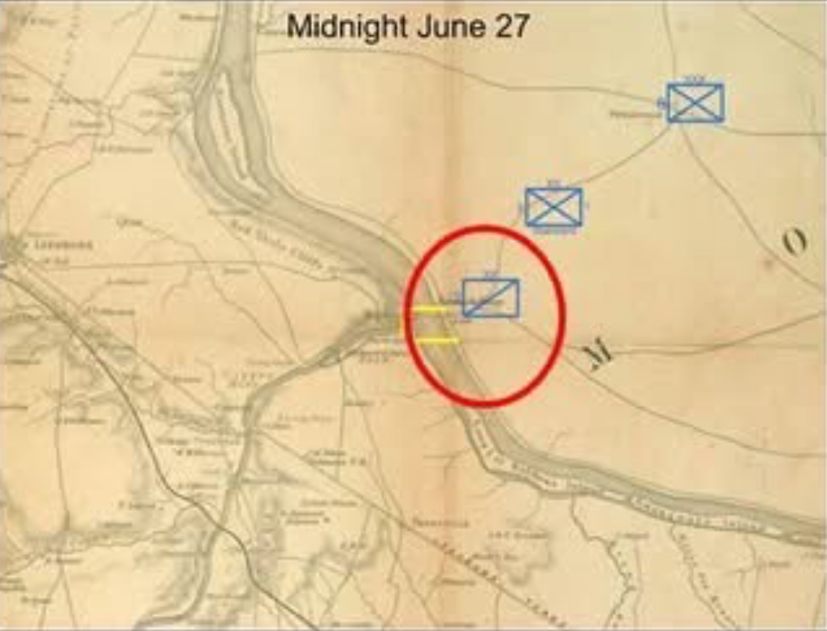
26 June – Friday – 14th Day on Campaign
Vicinity of Haymarket, VA to Poolesville, MD – 22 Miles
The Regiment is six days from its test of arms in the Wheatfield. Making an early start (First light approximately 0405, Dawn 0435) the Regiment moves approximately 22 miles (as per previous post) via Sudley Springs and Gum Springs (modern Arcola, VA) to Edwards Ferry on the Potomac River, just east of Leesburg, VA.

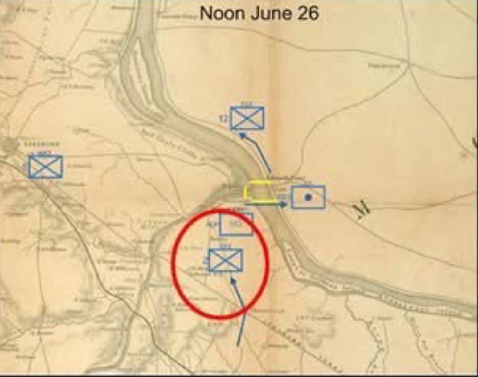
A cold rain falls, making roads muddy, but the Regiment arrives in the afternoon and goes into camp about a mile short of the crowded crossing point, to await its turn.
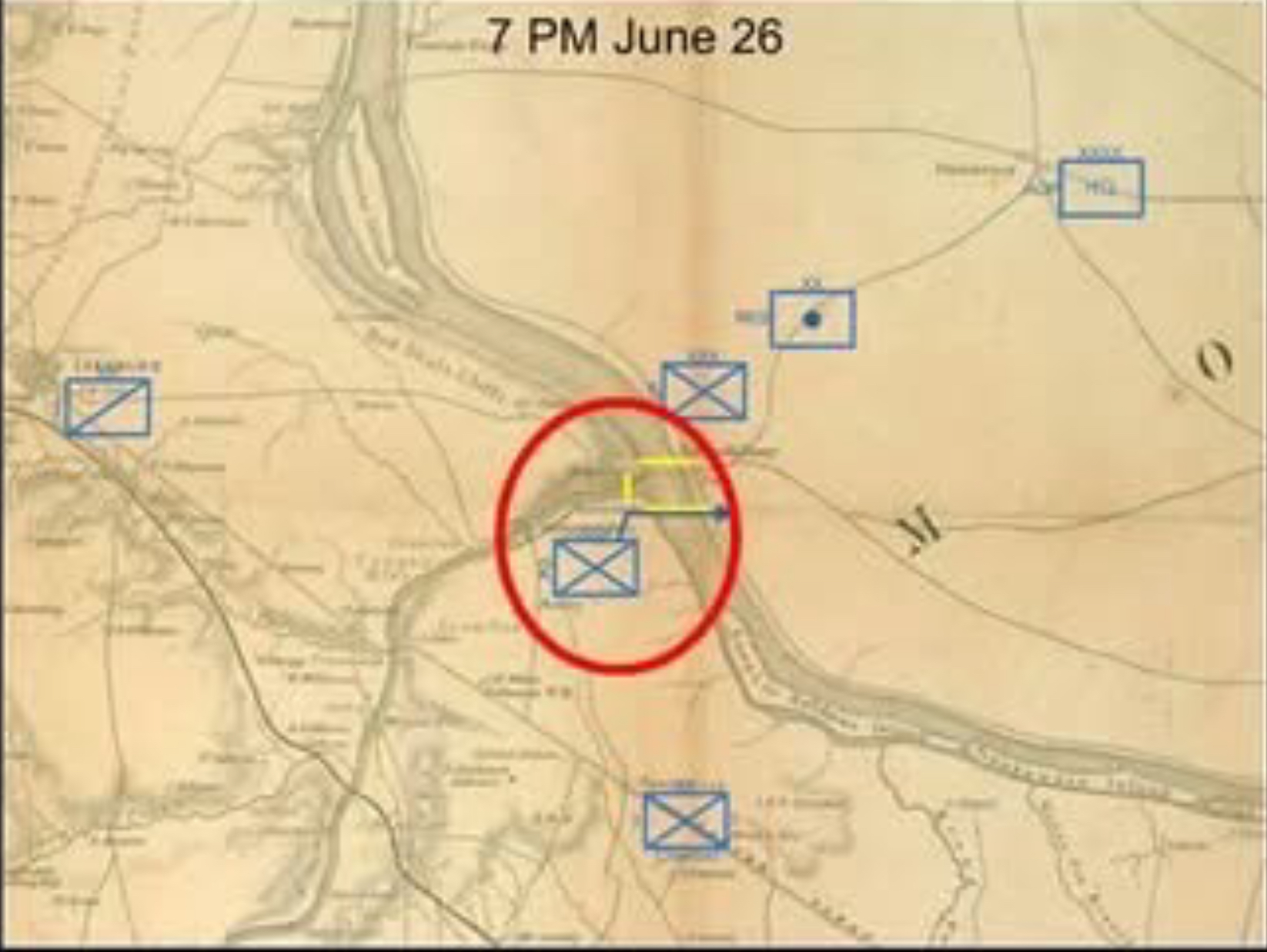
At dark (at bit after 8PM) the Regiment breaks camp, crossing the lower pontoon bridge over the river between 10PM (Ryan) & Midnight (Welsh). On the Maryland side, the Regiment proceeds about 2 miles in the direction of Poolesville, where, short of Poolesville, it rests.
Total distance covered since 14 June is about 115 miles.
For more on the movement of the II Army Corps across Loudoun County, VA, see this post from the “To the Sound of the Guns” Blog – the source of the maps associated with this post. (http://markerhunter.wordpress.com/2009/07/04/edwards-ferry-ii-corps-crossing/
NOTE – 26 June 2025: Craig Swain’s “To the Sound of the Guns” blog has apparently been retired. That said, an archival copy can be accessed at: https://web.archive.org/web/20110406222310/http://markerhunter.wordpress.com/2009/07/04/edwards-ferry-ii-corps-crossing/
27 June- Saturday -15th Day on Campaign.
Poolesville MD to Barnesville, MD – 7 Miles.
Weather: AM Showers, but clear later. The 28th Mass marched at 4PM through Poolesville, arriving at its night bivouac at Barnesville, MD between 11PM and 12 AM. (Ryan calls location “Brownsville.”) Route most likely along the today’s MD Route 109. Distance about 7 Miles; reported elapsed time indicates a very slow movement, no doubt the fact that the entire II Army Corps (11,350 men, 28 guns, and Supply train) were likely moving along this route a factor. (The OR notes in its “Itinerary of the Army of the Potomac and co-operating forces, June 5-July 31, 1863” that the II Army Corps moved “… from near Edwards Ferry, via Poolesville, to Barnesville, Md.” Presumably, this means that Major General Hancock’s HQ so moved; the bigger picture is that the AoP is gathering itself together as the battle approaches.)

Total distance covered since 14 June is about 122 miles.
28 June- Sunday – 16th Day on Campaign.
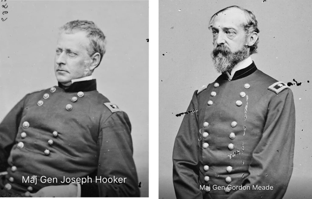

Weather: Once again, AM showers, but clear later. The big news this day is that Major General Gordon Meade of Pennsylvania is elevated to the command of the Army or the Potomac, replacing Major General Hooker. Father William Corby, Chaplain of the Irish Brigade’s 88thNY recalls that the change caused great grousing amongst the men about the qualities of generalship, and that some held to the belief that “surely Little Mac” (Major General George B. McClellan) had been placed back in command.
The 28th Mass marched at daybreak (between 0405 and 0435) through West Mills (location unknown) and Urbana MD, crossing what will be the 1864 Monocacy battlefield, and then the Monocacy River, before bivouacking near Monocacy Junction, 3 miles short of Frederick, MD. (Historical note: it was in this area that the famous “Lost Orders” of the Antietam Campaign were found.

This picture (of Brooks Hill on the Monocacy Battlefield) is just west of where the 28th MVI likely camped. It gives a good indication of what the countryside is like.
The day’s march was approximately 15 miles, likely on a route that moved NNE until reaching the Urbana Pike (modern MD route 355.)
Total distance covered since 14 June is about 137 Miles.
29 June- Monday – 17th Day on Campaign.
Monocacy Station, MD to vicinity Frizzleburg, MD – 32 miles.
Weather: A drenching rain all day; muddy roads. This day was perhaps the most physically challenging day of the campaign short of actually combat as the Regiment moves 32 miles in miserable conditions, routing through Libertytown, Johnsville, and Uniontown, to a point 2 miles short of Frizzleburg MD.
Father Corby of the 88th NY notes in his memoirs that each soldier carried about 60 pounds “…including his musket, cartridges, provisions, shelter-tent, and blanket.” Sgt. Peter Welsh’s letter to his wife after the battle described that only 40 of the regiment’s 225 men were present with the colors at the end of this exhausting march.
None of the first-person accounts I’ve seen mentions the Regiment marching through Frederick city, so I surmise that the Regiment skirted to the east of Frederick on the north bank of the Monocacy, before following the general trace of the Liberty Road (modern MD route 26) East to Libertytown before veering North to Johnsville and then NNE to Unionbridge along what is now MD route 75. From Unionbridge, the movement likely turned East, through Uniontown to the bivouac site.
The movement this day takes the Regiment – in fact, the entire II Army Corps – away from the Confederate invaders in Pennsylvania – why? The answer certainly relates to General Meade’s thinking regarding where to force or accept battle with the Army of Northern Virginia. Uncertain of Confederate intentions, and mindful of his orders to ensure he stayed between the Confederates and Baltimore and Washington, he had his engineers scout out possible battle locations that would favor the AoP. These were found along Pipe Creek, Maryland – Frizzleburg is generally in the center of what would become known as Meade’s “Pipe Creek Line.” It is also well located as a road hub. In my judgment, Meade situates the veteran II Army Corps, led by one of the most able Corps Commanders in the Army (and close friend) “Hancock the Superb”, as his Reserve, well positioned operationally to respond to any number of potentialities. Meade comes into much criticism for his “Pipe Creek Circular” of 1 July, but I believe that he is doing what Army commanders must do – that is, thinking ahead several steps in both time and space. (Operational Art)

Total distance covered since 14 June is about 169 miles.
30 June – Tuesday – 18th Day on Campaign.
Weather: Light rain early, overcast later. Becoming warmer. Full Moon. The Regiment remains in bivouac near Frizzleburg, MD.

1 July – Wednesday – 19th Day on Campaign
Frizzleburg, MD to vicinity Gettysburg, PA – 19 miles.
First Day of the Battle of Gettysburg. Weather: Light rain early, sunny in afternoon, warm and high humidity. The Regiment moves NNW up the Taneytown Pike, via Taneytown and then likely North through Harney MD (near the PA- MD border) where it moves on the Taneytown road (modern PA route 134) to a point 3 miles short of Gettysburg, where it camps. (This is approximately near the modern US 15 exit for the Taneytown Road.) The Taneytown Road runs North-South along the eastern edge of the eventual Union position along Cemetery Ridge. With the battle begun north and west of Gettysburg, it is likely that the Regiment heard the fighting and knew battle was near.
This day’s movement is approximately 19 miles, bringing the total distance covered since 14 June to about 188 miles.
2 July – Thursday – 20th Day on Campaign.
2nd day of the Battle of Gettysburg. Weather: Scattered drizzle early, very warm (Upper 80s) and humid as day progresses. The 28th Massachusetts Volunteer Infantry arrives on the battlefield via the Taneytown Rd at approximately 7AM. The regiment moves to the Center of the Union position on Cemetery Ridge. There, along with the other members of the Irish Brigade, it receives a General Absolution from Father William Corby of the 88th NY:

“Dominus noster Jesus Christus vos absolvat, et ego, auctoritate ipsius, vos absolvo ab omni vinculo, excommunicationis interdicti, in quantum possum et vos indigetis deinde ego absolvo vos, a pecatis vestris, in nomni Patris, et Filii, et Spiritus Sancti, Amen. ” (“Our Lord Jesus Christ absolve you, and I, by his authority, absolve you from every bond, excommunication, interdict, and in so far as I can and then I will absolve you, from your sins, in the name, of the Father, and of the Son, and the Holy Ghost, Amen “)
Following from the tactical implications following from Sickles’ infamous salient, the Regiment in late afternoon is rushed to attack Confederate forces driving Sickles’ III Army Corps backwards (east) towards Cemetery Ridge. The Regiment, along with the entirety of the 2d Division, pivots and attacks into the flank of Confederate Forces. (See map. Broadly, this movement is south from the Trostle Woods across the Wheatfield and into the Rose Woods and the Stony Hill on the west side of the Wheatfield. (The Regimental monument on the Gettysburg Battlefield is on the Stony Hill.)

The melee in the Wheatfield becomes a legendary slugfest, and although the II Army Corps Federals initially blunt the Confederate attack, they are eventually driven off by new Confederate forces. Here is the Commander of the Regiment (Colonel Richard Byrnes) official report of the action:
“At 3 p.m., July 2, the order was given to advance, and the regiment proceeded a short distance forward and to the left, and then was ordered back to its original position. Soon after was ordered to move to the left, and about 5.30 o’clock became engaged with the enemy, who were posted in an advantageous position on the crest of a rocky hill. We forced them to retire from this eminence, and advanced over the top and almost to the bottom of the other side of the hill, being all the time exposed to a very severe fire of musketry, and losing many men in killed and wounded.
About 7 p.m., finding all save this regiment were retiring from the hill, and that the enemy were on both our flanks, as well as in front, I brought my command from the field, losing many men from the concentrated fire of the rebels. Our loss in this action was 100 in killed, wounded, and missing, out of 224 taken into the engagement.
I reformed the regiment, and rejoined the brigade near the Second Division hospital about dark, and soon after were moved to the front, where we remained all night.”
Total distance covered since 14 June is about 191 miles.
NOTE: As this account has focused on the Regiment’s March to Gettysburg, I have purposely not gone into detail about the fight in the Wheatfield. In the Gettysburg Campaign, the 28th MVI had a total of 107 men killed, wounded or missing. Go mbeadh trócaire ag Dia ar a n-anamacha. (Irish: May God have mercy on their souls.)

3 July – Friday) – 21st Day on Campaign.
3rd day of the Battle of Gettysburg. The Regiment remained in position on Cemetery Ridge. Here continues Colonel Byrnes’ official report, picking up from the point where yesterday’s post ended:
“…in the morning erected breastworks of rails and earth, behind which we remained throughout the entire day, during the greater portion of which the enemy kept up an extremely heavy fire of artillery, and made two attempts to force our lines, but were repulsed on each occasion with great loss. On account of being sheltered by our earthworks, which we erected on the 3d instant, we suffered no casualties from the enemy’s fire.”
This entry ends my series of posts on the Regiment’s march to Gettysburg. The Regiment, as part of the II Army Corps would participate in the pursuit of the withdrawing Army of Northern Virginia starting on Sunday 5 July, moving first to Two Taverns, then on south through Taneytown, MD (7 July), Frederick, MD (8 July), and other locales, before crossing the Potomac at Harpers Ferry (18 July). As the fateful summer of 1863 passed into memory, further marches took the Regiment south towards the line of the Rappahannock and Rapidan, where the Overland campaign of 1864 would await.

28th Massachusetts Monument at the Gettysburg NMP
The monument is a granite shaft topped by a marble American Eagle, standing 13′ 4″ tall. The face of each side has a different symbol: the Shield of the United States, the trefoil of the Second Corps, the Coat of Arms of the State of Massachusetts, and the harp of Ireland. The regiment’s motto, FAUGH A BALLAUGH (“Clear the way,” in Gaelic) is at the top of the front. The monument was erected by survivors and friends of the regiment in 1885.

Inscribed on the monument is the following:
28th MASS INFY
VOL.
COL RICHARD BYRNES COM
MEAGHERS IRISH BRIG.
COL PATRICK KELLY COM
THIS REGT WENT INTO BATTLE
JULY 2, 1863
NUMBERING 220
OFFICERS AND MEN
101 OF WHOM
WERE KILLED OR WOUNDED
ERECTED BY THE SURVIVORS
AND FRIENDS OF THE REGT.
TO MARK THE SPOT WHERE IT
FOUGHT IN DEFENCE OF THE
AMERICAN UNION
BIBLIOGRAPHY
Adkin, Mark. “The Gettysburg Companion: The Complete Guide to America’s Most Famous Battle.” (2008)
Barnard, Sandy (editor). “Campaigning with the Irish Brigade Pvt. John Ryan, 28th Massachusetts” (2001)
Coddington, Edwin B. “The Gettysburg Campaign: a Study in Command.” (1984).
Conyngham, David P. “The Irish Brigade and Its Campaigns” 1994 reprint , original 1867.
Corby, William C and Kohl, Lawrence. “Memoirs of Chaplain Life: 3 Years in the Irish Brigage with the Army of the Potomac (The Irish in the Civil War)(1992).
Gottfried, Bradley M. “the Maps of Gettysburg: an Atlas of the Gettysburg Campaign, June 3-July 13, 1863.” (2007)
Jones, Paul. “The Irish Brigade.” (1969).
Kohl, Lawrence and Richard, Margaret Cosse. “Irish Green and Union Blue: The Civil War Letters of Peter Welsh, Color Sergeant, 28th Massachusetts (The Irish in the Civil War)(1986)
O’Brien, Kevin E. “The Irish Brigade in the Wheatfield” – essay included in “the History of the Irish Brigade” (Seagrave, Pia, editor), 1997
Reardon, Carol. “The Gettysburg Campaign: June -July 1863.” The US Army Campaigns of the Civil War. (2025)
Smith II, James M. “Storming the Wheatfield: John Caldwell’s Union Division in the Gettysburg Campaign.” (2019).
Author: Jerome Lynes 2013, Revised 2025. Contact the Author